Take a Ride on the Great Northern!
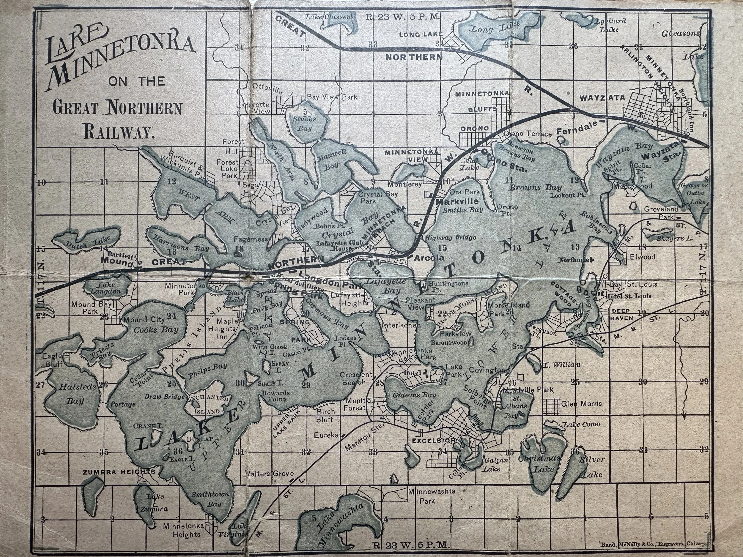
Lake Minnetonka almost certainly wouldn’t be what it is today without the initial influence of the railway. The rails to Wayzata were built and operated by the Saint Paul, Minneapolis, and Manitoba Railway in 1867 but our view here is a bit more recent. The photos shown above and below are part of a Great Northern Railway time card from July 12, 1903. I would encourage you to take a moment to scan the map above to see just how different the Lake Minnetonka area was at that time. Let’s take a quick moment to note just the differences along the railway.
Most notably, the southern section of the tracks–from Ferndale to the extreme western edge of the map—is no longer an active railway. Rather, this stretch of land has since become the Dakota Rail Regional Trail. Long time residents might also recognize it as the old “Hutch Line.” Along Wayzata Bay, we can see a marking for the Great Northern’s easternmost Minnetonka station: the Wayzata Depot. Though, you might wonder why it’s depicted on the opposite side of town from where it is today. In truth, this is no error. The history in this depot is filled with grudges, lawsuits, and malicious intent.
Following Wayzta’s 1883 incorporation, the village’s first order of business was to file a lawsuit against the railway with a goal of having the tracks moved off Lake Street and rebuilt further uphill. When J.J. Hill lost the suit he abided by the judgement and moved his tracks off the road. . . and closer to the lake.(1) As repayment for their suit, he demolished the original 1867 station, which stood at the intersection of Lake Street and Broadway Avenue, and built a new one further east. His attitude toward Wayzatans was a cold one. “Let them walk a mile for twenty years” was his motto, and he stuck to it. The townsfolk did, indeed, have to walk a mile for twenty years until Hill erected a new station in 1906 next door to Moore Boatworks. With that in mind, let’s head west on the line to Navarre!
Wait. . . Where is Navarre?
Before being renamed to Navarre, this little township was dedicated to a beautiful French town: Landon Park. The town was central on the lake but wedged between Hotel Del Otero and Hotel Lafayette. However, the Langdon Park station served mainly cottagers who owned land on or near Crystal Bay, West Arm, Lafayette Bay, and Carman’s Bay. Heading further west, the Spring Park station would have stood on the northwest corner of where, today, the Dakota Trail intersect with Sunset Drive. Its location was no random spot, being essentially in the back yard of Hotel Del Otero. This hotel was built by the railway in the late 1880’s and proved a hugely successful business until it burnt to the ground in early July, 1945.
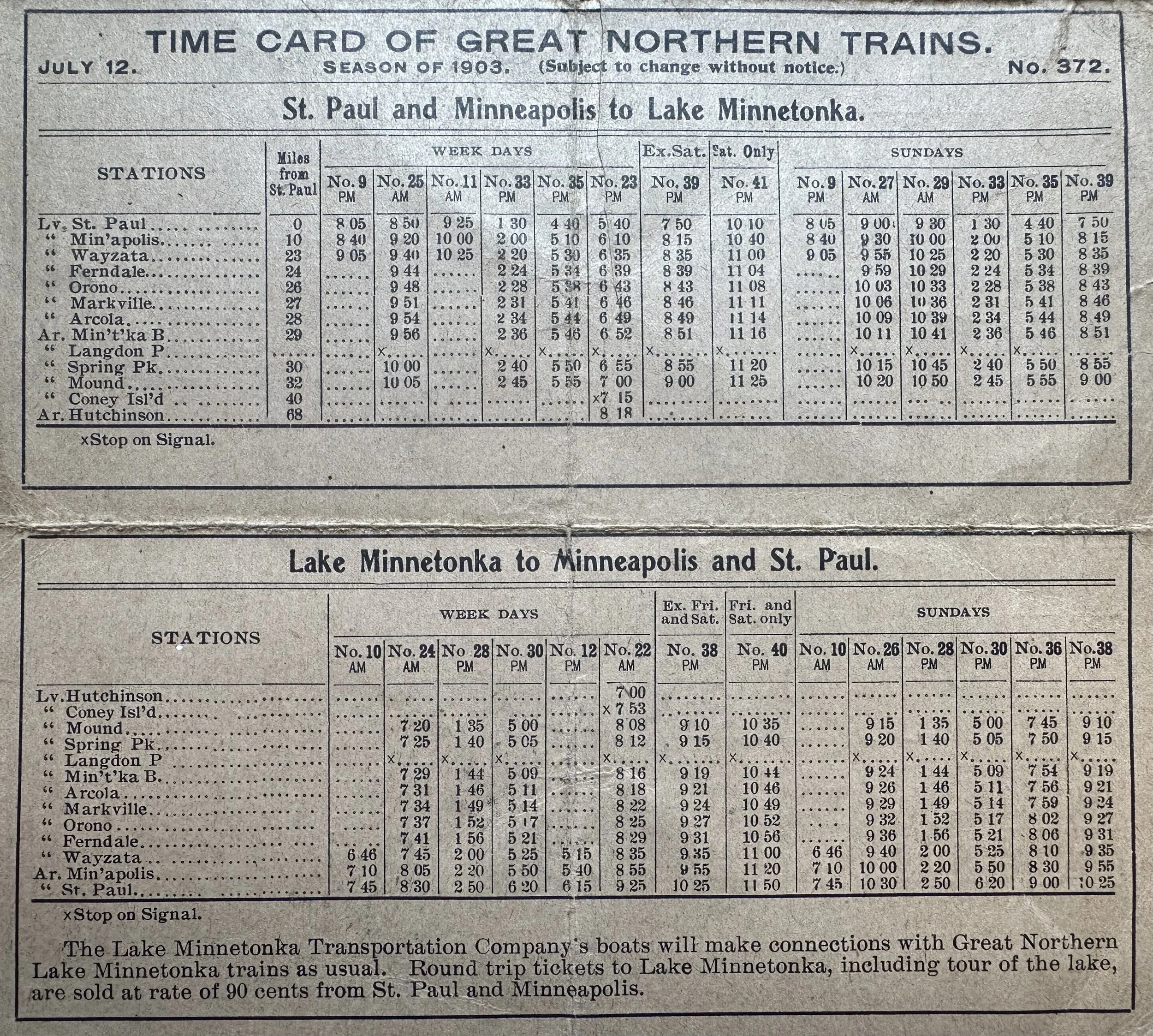
The time card on the reverse side of the map shows all the Minnetonka area stations, departures, arrivals, and times. Visitors could purchase a ticket on the train and take a tour of the lake by steamboat for just 90¢. That’s roughly $35 today which, quite honestly, is an absolute steal! In 1903 the Lake Minnetonka Transportation Company—owned and operated by captain John R. Johnson—was not only the most prominent navigation company on Minnetonka but also experiencing its heyday.
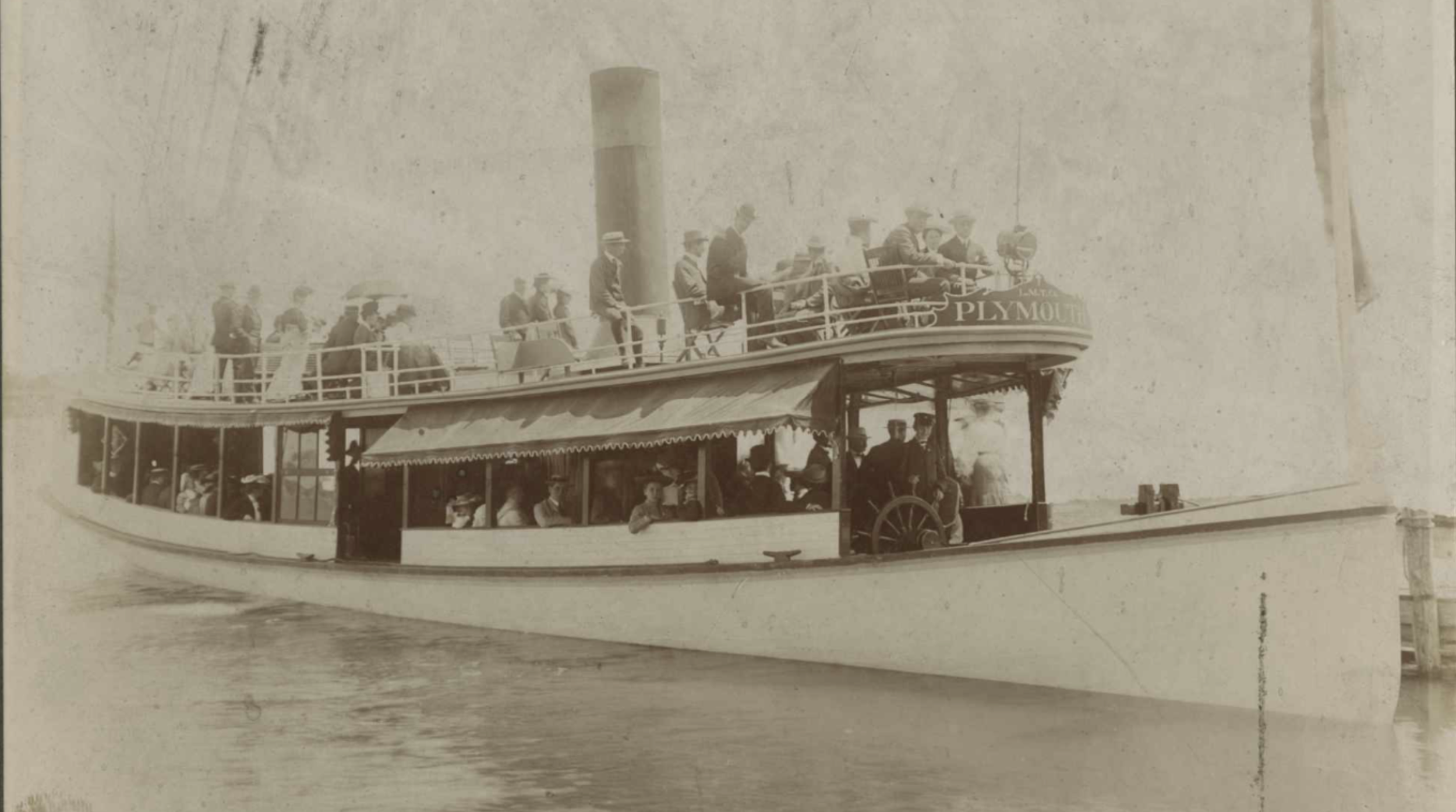
Tourists using this time card to visit the lake would almost certainly be hopeful to take a ride on Johnson’s newest boat, Plymouth which had been launched in May of that year. The 81’ long and 13’ wide Plymouth was the company’s new flagship and measured in as one of the larger boats in their fleet. Just three years later, Johnson would sell her in a lot to the Twin City Rapid Transit Company as they burst onto the Minnetonka scene with unbeatable boats and pricing. Plymouth would be scrapped by the company in 1915 after only 12 years of service.
Ultimately, it’s almost impossible to overstate the impact which the Great Northern Railway and its predecessor had on Lake Minnetonka. Without its influence, our community would have had a substantially weaker history, less prominent figures, fewer businesses, and who knows what else. The survival of time cards such as this go a long way toward helping preserve the details of the train’s operation and just how vital they were to the area. Having nine stations built in a relatively undeveloped area displays this relationship clearly:
Lake Minnetonka fed the railway and, in return, the railway put Lake Minnetonka on the map.
Learn more about the Lake Minnetonka Transportation Company below!
Footnotes:
Hill did not lose the initial suit, rather, he lost a second suit on the same matter.
Bibliography of Sources:
J.J. Hill Dispute: https://jamesjhilldays.wayzatawestmetrochamber.com/history/
Wilson Meyer, 1997, Lake Minnetonka’s Historic Hotels
McGinnis, 2010, A Directory of Old Boats
Photo of Plymouth - Lake Minnetonka Historical Society
1903 Great Northern time card & map - Minnetonka Minute private archive